What Are Those Lines On The Marshes For?
Tackling the tough questions...
 |
| Duxbury Beach |
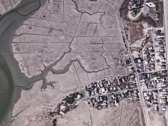
If you should ever have cause to view Duxbury Beach from the sky, you'll notice something odd about her marshes. You'll see regular rivers, like the Cut River on the left in the photo above, and you will see her nameless tributaries.
Those lines are definitely man-made, and- no- they don't spell something if you turn the map sideways and look at it all cockeyed. I checked.
It's not just Duxbury, either. I stole pictures from Fairhaven, Bridgewater, Brewster and Gloucester. I could have stolen them from Gloucester, North Carolina if I needed to, and I could probably find these lines in marshes all the way to Colombia.
 |
| Brewster |
Colombia is mentioned because they are involved in the answer. No, the answer doesn't have cocaine in it. We'll get to Colombia in a minute.
First, some geography. Anywhere that a river empties into the sea tends to be swampy. The rivers wash soil down from upstream, and the soil forms the basis of the marsh. Marshes tend to have terrific soil, and they produce top-notch hay for livestock.
We actually did this article once and blamed the salt marsh hay industry for the lines, but we were incorrect. The salt marsh hay trade in Marshfield, for instance, was ruined after an 1804 hurricane changed the course of the Green Harbor River. These lines are from a century and change later.
These marshes fill with water when the tide comes in, and they empty when the tide goes out. They do not empty completely, however, and that is where problems start.
Off to Colombia we go...
 |
| West Island, Fairhaven |
OK, that's Fairhaven above, not Colombia, but she'll pass in a pinch.
When the Panama Canal was being dug, both by France and later the USA, people died by the bushel-basket. Accidents were part of it, but the big killers were Yellow Fever and Malaria. France lost 22,000 men before giving up on the Canal, and the US sent 5000+ to the grave while they were building it.
As the Canal was being built, they made great strides against these diseases. This wasn't long after we fought a war in Cuba, which was also malaria-crazy. Yellow Fever is why Haiti isn't still French.
The first step to fighting it was figuring out that mosquitos were the vector for the disease. Much like the Black Death in older times, pests like skeeters and fleas spread the disease to both rich and poor. Even in modern Africa, a child dies every 30 seconds from a mosquito borne disease.
The second step was killing off the mosquitos. A series of measures were enacted, ranging from simple things like "putting up screens" to more complex issues like "sanitizing the water supply" and "draining stagnant water."
Mosquito-borne illness was nearly eliminated, the Canal was finished, and things now shift to Massachusetts.
 |
| near Good Harbor Beach, Gloucester |
Mosquitos did damage up here, too. Yellow Fever epidemics killed 40,000 in New Orleans as recently as 1905. Eastern Equine Encephalitis still kills people in Massachusetts. 15,000 US citizens still get Malaria in 2022.
With the treatment of mosquito-borne illness causes showing great results, we decided that what is good for the Cartel is good for the Country. While the US is much larger than the Colombia/Panama region, our resources dwarf theirs.
Massachusetts was not immune to mosquito-borne illnesses. Duxbury, the town featured in the first photograph, was almost uninhabitable at her beach area due to clouds of mosquitos. There is still a part of Duxbury called Mosquito Village, and it is near a marsh.
 |
| Mosquito Village, Duxbury |
After World War II, the US had several things. They had a million+ soldiers returning from Europe. They had a great need for busy work. After fighting in Africa and the Pacific, they also had a great deal of DDT, an insecticide that is very effective against mosquitos. DDT is what Jake The Snake's finishing move is named for, in case you were wondering.
A vast, nationwide mosquito control program was taken up. Trucks rolled through coastal communities, fog-spraying DDT everywhere. Kids of that era used to chase the DDT truck and play in the mist.
Eliminating stagnant pools of water was also part of the process, and was undertaken 20 years before they were spraying DDT everywhere. Wiping out standing pools of water was as simple as kicking over buckets of water, and as complex as draining 1200 acre marshes. This is where those lines come in.
 |
| (Duxbury... during droughts, the canals get taller grass, due to the passage of sea water) |
At some point in the 1930s, workers were sent into the marshes off Duxbury (seen in the picture above) to make sure that the water drains. Mosquitos need stagnant water to breed. They can't lay eggs on moving water, especially where fish are. Big, isolated pools of marsh water are what they like, and the canals that the workers cut drained those away.
The mud taken as the canals were dug may have been dumped over the dunes onto Duxbury Beach to keep it from filling the canal holes back in. The resulting mud flats are still very visible today on Duxbury Beach. Mud flats are not seen in 1860s pictures of areas where they are now.
I should add that I spoke to an eyewitness to trench digging in Eastham who told me they just chucked the mud off to the sides of the trench, so I could be 100% wrong. My other wild guess is that the two mud flats on Duxbury Beach are either side of the former (pre-1804) mouth of the Green Harbor River. It could also just be sea level change stuff.
They did some damage to the local ecology. DDT turned out to be a bird killer, and if you read Silent Spring, you know that DDT use and the damage that followed was the main topic. Duxbury's DDT/bird kill was the impetus for this book.
Many birds and fish were dependent on mosquito larvae, and they also suffered. The marsh became very barren of diverse nature for some time after, although it is bouncing back.
Some will disagree, but others will say that is a small price to pay for wiping out the skeeters. Horseflies, which nest on the land parts of the marsh, flourished in the absence of mosquitos, and there are a few weeks in the summer where it is risky outside. Horseflies are what those boxes you see on marshes are meant to control.
Those canals seem to be pretty much self-maintaining, and I lived on Duxbury Beach for 32 years without ever seeing a crew out there fixing them. As the area became more inhabited, it is difficult to guess how many lives these canals have saved. Well, human lives. It was pretty much a mosquito genocide.
You can still be bitten by a mosquito in these areas, but the risk is much lower than it was a century ago in the same places. Really old locals rarely complain about the bugs at the beach. Mosquitos tend to breed in forests now, and the EEE risk has shifted from coastal areas like Duxbury to swampy interior areas like Halifax and Bridgewater.
 |
| Hockomock Swamp, Bridgewater |
So, anyhow, that's what those lines are for. You can sleep easy now.

.jpg)

Comments
Post a Comment